

Charts of the English Channel and North Sea
The Channel and North Sea charts cover a large area from the Belgian coast to the Channel Islands. Depending on your needs, you will choose charts SHOM to work on large scales and the NV-Charts, Navicarte or Imray for smaller areas on smaller scales. Find a complete range of nautical charts on Picksea.com!
THE MARINE CHART, INDISPENSABLE FOR NAVIGATION
It is important to remember that nautical charts give more or less detailed indications depending on the scale and the use according to the type of navigation you are planning: the larger the scale, the less details the chart gives and vice versa. It is often very useful to complete the charts with a nautical guide such as the Marine block. Knowing how to use your chart is just as important in order to navigate in the best possible conditions, so find all our advice for how to read and use your navigation chart
NAVIGATION CHART FROM THE CHANNEL TO THE NORTH SEA
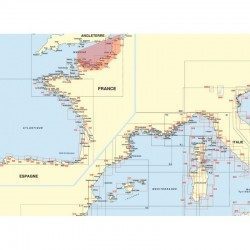
Find a complete range of nautical charts, covering the French and English coasts and ports from the English Channel and the North Sea to Belgium. You will find maps detailing information on the many existing Traffic Separation Schemes as well as for many important ports such as Dunkerque, Calais, Boulogne, Dieppe, Le Havre and Cherbourg. The islands Channel Islands are not forgotten with very detailed maps of these "reserves of British charm" which remain nevertheless not easy zones considering the currents, the important tidal range and the numerous reefs which surround these islands. In addition to these sailing areas, you will also find world nautical charts whole : Overseas, North Brittany, South Brittany, Atlantic coastline or even Mediterranean Sea.
LAMINATED CHARTS FOR COASTAL NAVIGATION
Less cumbersome than the classic charts, but just as well thought out visually, the claminated navigation charts are perfect for kayaking, catamaran sailing and coastal navigation in general. In A3 format with a scale adapted to each navigation basin, the laminated map is easy to use on board your boat, as it is not affected by water. Thus, it will be less complicated than with a classic map to define a position or to trace a route
OFFSHORE CHARTS FOR OFFSHORE NAVIGATION
Much less detailed than plastic maps, the offshore navigation charts are designed for offshore navigation. Plan, prepare and follow your crossing in a simplified way! Indeed, this type of chart covers a large area and contains few detailed symbols. Offshore charts also allow you to choose between different routes and options with the presence of important traffic lights and distances between potential ports of call
SHOM CHARTS FOR EXAMS AND LICENCES
Picksea is an Authorised Agent of SHOM (French Naval Hydrographic and Oceanographic Service) for several years now. On our website you will find a full range of nautical documents and charts designed by this organisation. As an agent of SHOM, we offer you, among the examination Chartsthe two official charts for the French exams, the chart 9999 for the deep-sea license, and the chart 7066 for professional maritime exams
Are you looking for a specific navigation chart? Contact our teamWe will order it for you!
Read more
There are 8 products.
-
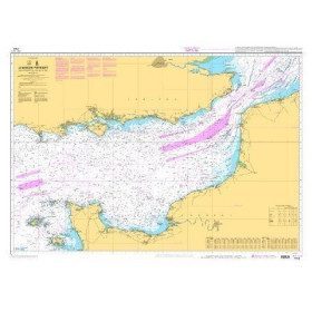
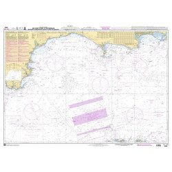
<p style="text-align:justify;">Shom 7311 nautical chart for cruising in the Channel : Scilly, Ouessant, Jersay, Guernsey, everything is there.</p>
available
-
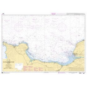
<p style="text-align:justify;">Shom 7312 marine chart for your cruising or racing in the Eastern Channel. From Casquets to Pas-de-Calais. Scale 1:375000</p>
available


-
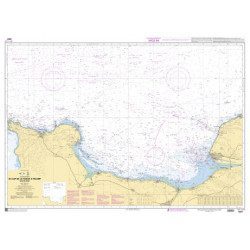
<p style="text-align:justify;">Shom 6857 marine chart for your cruising or racing in the Bay of Seine. From Cap de la Hague to Fécamp. Scale 1:150 000</p>
available
-
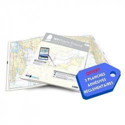
<h2>NV-CHARTS FR1 - 48 Channel Charts (Oostende to Cherbourg) + the 3 regulatory adhesive sheets</h2>
<p style="text-align:justify;"><span style="font-size:10pt;">In this NV-Charts FR1 pack, you will find an Atlas of 48 nautical charts from Oostende to Cherbourg including 4 offshore charts, 15 coastal charts and 29 detailed charts. Thanks to a personal download code, you will have access to all the charts in digital format as well as to the <strong>NV Graphical Navigator light navigation software</strong> both freely usable on PC, tablets or smartphone!</span></p>
<p style="text-align:justify;"><span style="font-size:10pt;">The area represents the Channel (FRANCE), and more precisely the following areas: <strong>Normandy - Zeebrugge, Dunkirk, Calais, Le Havre, Cherbourg.</strong></span></p>
<p style="text-align:justify;"><span style="font-size:10pt;"><span style="color:#ff0000;background-color:#ffffff;"><strong>Free with your FR1 pack:</strong></span> 3 adhesive sheets containing the mandatory regulatory documentation (RIPAM, buoys and flags) for navigation in coastal areas (art 242-2.04 of Division 240). <span style="color:#ff0000;"><strong>When you buy your pack, you have all the regulatory documentation for sailing within 6 miles of a shelter.</strong></span></span></p>
<h2>Description of the FR1 card pack</h2>
available
-
available
-
available
-
<h2>NV-CHARTS FR2 - 25 Western Channel Charts (from Cherbourg to St Malo) + the 3 regulatory adhesive sheets</h2>
<p><span style="font-size:10pt;">In this NV-Charts FR2 pack, you will find an atlas of 25 nautical charts from Cherbourg to St Malo, including 2 deep-sea charts, 14 coastal charts and 9 detailed charts. Thanks to a personal download code, you will have access to all the charts in digital format as well as to the <strong>NV Graphical Navigator light navigation software</strong> both freely usable on PC, tablets or smartphone!</span></p>
<p><span style="font-size:10pt;">The area represents the Channel (FRANCE), and more precisely the following areas: <strong>Channel Islands - Cherbourg, Granville, Chausey, Jersey, Guernsey, Cancale, Saint Malo.</strong></span></p>
<p><span style="font-size:10pt;"><span style="color:#ff0000;"><strong>Free with your FR2 pack:</strong></span> 3 adhesive sheets containing the mandatory regulatory documentation (RIPAM, buoys and flags) for navigation in coastal areas (art 242-2.04 of Division 240). <span style="color:#ff0000;"><strong>When you buy your pack, you have all the regulatory documentation for sailing within 6 miles of a shelter.</strong></span></span></p>
<h2>Description of the FR2 card pack</h2>
available
-
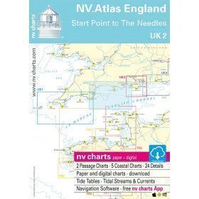
<h2>North Sea Zone Sea Card Packs</h2>
<p>The nv-charts are characterized by fine contours and easy to distinguish colour graduations of the depth lines: turquoise for coral reefs, red for the 2-metre line and blue for the 5-metre zones. Presented in a practical and user-friendly format (A3 closed and A2 open), a thick plastic envelope protects the charts, making them easy to store. The importance of a good graphic representation of the topography when navigating the North Sea is essential.<br /><br />Well-marked rivers, towns and street maps all contribute to a clear overview of the islands' waterfront facilities. Red numbered waypoints with coordinates based on WGS 84 allow mariners to navigate with their GPS instruments. Heights and depths are shown in the internationally recognized metre format. Large-scale approaches and land contour markings simplify entry into anchorages.</p>
<h2><span style="color:#ff0000;">Picksea is Premium Reseller of NV-Charts</span></h2>
<h2>NV-Charts North Sea Zone Marine Card Packs Features</h2>
available


Showing 1-8 of 8 item(s)