available


Detailed features

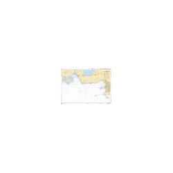
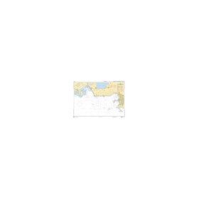
SHOM chart 7066 : from Ile Vierge to Penmarc'h
The SHOM 7066L chart is the marine chart of the tip of Brittany. It can be used for navigation but above all it is used as a support for professional maritime exams: Captain 200, Chief of the Watch 500, Captain 3000 or Unlimited. It exists in folded or flat version.
Characteristics of the SHOM 7066 chart
- Scale: 1/158800
- Folded size A4 (297 x 210 cm)
- Open size A0 (84 x 119 cm)
You might also like 3 other products seleted for you
-
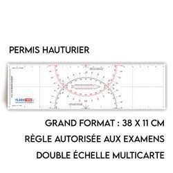
<h2>Flash-Tide - Cras 2000 two-tone ruler</h2>
<p style="text-align:justify;">The Flash-Tide Crash Ruler 2000 is a two-tone red and black crashed ruler that is very popular with boaters and offshore license applicants because it is more practical and easier to read than traditional crashed rulers.</p>
<h2>Details of the Cras 2000 rule</h2>
available

-
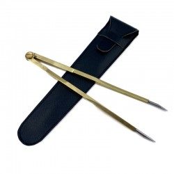
<h2><strong>Straight Brass Divider</strong></h2>
<p><strong></strong>Brass compass for esthetics with fine stainless steel tips for accuracy of measurement.</p>
<p>Interactive instructions online at <a href="https://www.youtube.com/user/PickseaVideo" target="_blank" rel="noreferrer noopener">PickseaVideo</a></p>
<h2>Features of the Flash-Tide Straight Brass Divider</h2>
available
-
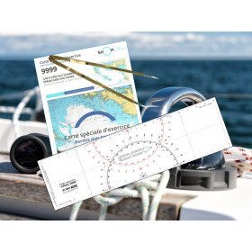
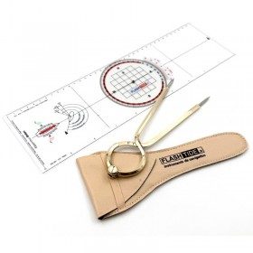
<h2 id="prod-h1" class="prod-name">Protractor Ruler and Compass Kit</h2>
<p style="text-align:justify;">Set of equipment to prepare for the offshore licence or to equip your boat, including a Brocémer ruler (Flash-Tide) and a dry point compass (Flash-Tide)</p>
<h2 style="text-align:justify;"><span>Features of the Protractor Ruler and Compass Kit</span></h2>
available


In the same category
4 other products seleted for you-
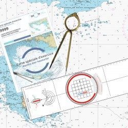
<h2><strong>The offshore licence pack with Breton plotter !</strong></h2>
<p>Pack of material to prepare the offshore licence including the official chart 9999, a plotter (Flash-Tide) and a one hand divider (Flash-Tide)</p>
<h2>Features of the Offshore Plus Pack</h2>
available
-
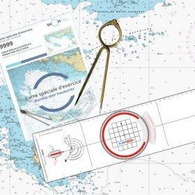
<h2><strong>The essential pack to prepare your offshore licence</strong></h2>
<p style="text-align:justify;">A set of quality tools to pass your offshore licence! Picksea is the owner of the Flash-Tide Instruments brand and our teams manufacture in France, in Lorient, all models of <a href="https://www.picksea.com/en/106806-cras-navigation-rules">rules cras</a> or Breton. Picksea is also a SHOM agent. We are therefore the best able to provide you with a pack composed of the best products at the best price.</p>
<h2>Composition of the offshore licence pack</h2>
available
-
<p class="t12px">Marine chart shom <span class="searchproduct-list-item-name">6767 </span>for navigations along the blue coast and in the roadstead of Marseille until the calanques<span class="t12px">. Nautical chart SHOM type Carte L folded in A4 format <span class="t12px">or flat</span> </span>, for pleasure boating. Up to date printing Scale <strong><strong>1 : 50 000</strong><br /></strong></p>
available
-
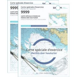
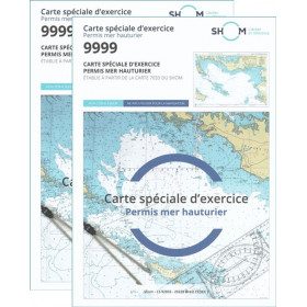
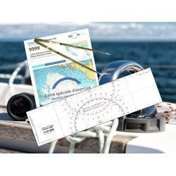
<h2>Pack of 2 official 9999 marine charts from SHOM</h2>
<p style="text-align:justify;"><span>The nautical chart of SHOM 9999 is the official chart of the exam of the <strong>offshore sea permit</strong> which allows to navigate beyond 6 miles from a shelter. It is also on this chart that you will do all the exercises to prepare you for the exam </span></p>
<h2 style="text-align:justify;"><em>Why buy 2 charts?</em></h2>
<p style="text-align:justify;">The fact of doing many exercises on the chart (with a lot of deletion) often makes it unusable for the exam and this is why many exam centers require a new chart for the exam. It should be noted that the organising administration keeps the card as a copy of the exam (except in the case of failure).</p>
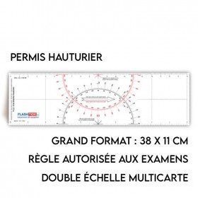
<h2>Training and preparation for the offshore licence (theoretical test)</h2>
<p style="text-align:justify;">After passing the coastal licence (and perhaps also the inland waterways licence), you wish to extend your navigation area to the "high seas"! To do this, you need to obtain a deep-sea licence to sail motor yachts beyond 6 miles from a shelter (but it is also very useful for sailing). Read our<a title="Tout savoir pour passer le permis hauturier" href="https://blog.picksea.com/tout-savoir-passer-permis-hauturier/" target="_blank" rel="noreferrer noopener"> article "Everything you need to know about the offshore licence"</a> to find out more.</p>
<p style="text-align:justify;">The chart SHOM 9999 is a special marine chart but it contains all the information of a real navigation chart (scale of latitudes and longitudes, coasts, probes, dangers, beacons, lighthouses, currents, ...). You can plot routes and bearings as well as position points, or measure distances as on a real chart <a title="Déterminer une route sur le carte marine" href="https://blog.picksea.com/determiner-route-direction-distance/" target="_blank" rel="noreferrer noopener">See the article "Determining a route in direction and distance" on our blog </a></p>
<h2 style="text-align:justify;">Characteristics of the Marine Chart 9999 from SHOM for the Offshore Permit</h2>
available