available


Detailed features

Choose from the list below an unfolded nautical chart covering the major sailing areas of the world
These maps covering huge areas of navigation are frequently used as a decorative element or as a support to retrace a journey between continents. Choose in the list below the area you wish to explore by referring to the map number associated with the desired navigation area. Indicate the map number you have chosen in the comments of your order.
List of references for charts and areas covered:
| 5417 | North Atlantic Ocean and Boreal Seas |
| 6561 | Oblique conformal map of the North Atlantic Ocean. France-Antilles - Route du Rhum |
| 6808 | South Atlantic Ocean - Eastern part |
| 6809 | Indian Ocean , Southern part |
| 6815 | North Atlantic Ocean - Eastern part |
| 6835 | North Pacific Ocean - Eastern part |
| 6884 | Indian Ocean - Northern part. |
| 6964 | From Panama to Cape Horn (Câbo de Hornos) |
| 6977 | North Pacific Ocean - Northwestern Portion |
| 7021 | North Pacific Ocean - Southwestern Portion |
| 7023 | From San Francisco to Lima |
| 7043 | North Atlantic Ocean - Western part |
| 7044 | From Tierra del Fuego to Venezuela |
| 7166 | South Pacific Ocean - West Part |
| 7246 | French Polynesia |
| 7271 | Australasia and adjacent seas |
Consult the entire catalogue of SHOM charts on line by clicking HERE
You might also like 3 other products seleted for you
-
<div class="fiche-txt">
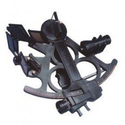
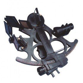
<h2>Sextant Davis Mark 15 from Topoplastic!</h2>
<p>This sextant is the reproduction of a real professional sextant. It is made of modern plastics, but it remains undeformable, shockproof and corrosion-proof. Light, robust and precise, this sextant is an indispensable navigation accessory. The Davis Mark 15 allows you to accurately determine all the points necessary for coastal and astronomical navigation.</p>
<h2>Detailed specifications of the Sextant Davis Mark 15 :</h2>
</div>
available

-
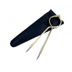
<h2>One Hand Brass Divider</h2>
<p style="text-align:justify;">One hand brass divider for aesthetics with fine stainless steel points for accuracy of measurement. The one hand divider is an indispensable marine instrument for measuring distances on a nautical chart whatever the scale, for determining its position in latitude and longitude or for positioning a point on the chart.</p>
<h2><span>Features of the One Hand Divider</span></h2>
available
-
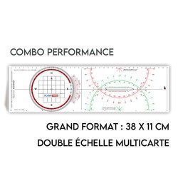
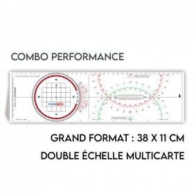
<h2>All the possibilities of the Cras rule and the Rappporteur Breton</h2>
<p style="text-align:justify;"><span>The Antares protractor ruler is both a tricolour Cras ruler AND a Breton protractor. It can be easily adapted to any skipper or sailor, whatever his or her initial training or practice habits. </span></p>
<h2>Features of the Antares rule</h2>
available

In the same category
4 other products seleted for you-
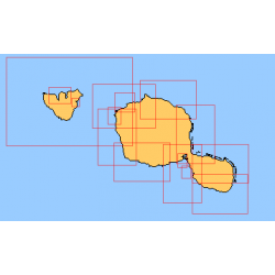
<div class="fiche-txt">
<h2>Choose from the list below an unfolded nautical chart of the sailing areas around Tahiti and the Society Islands</h2>
<p>This set of charts covers the whole of the Society Islands in unfolded Shom marine charts delivered in a tube. These charts detail the exact navigation areas of the islands. Choose from the list below the area you wish to explore by referring to the chart number associated with the desired navigation area. Indicate the map number you have chosen in the comments of your order.</p>
<h2>List of chart references and areas covered:</h2>
</div>
available
-
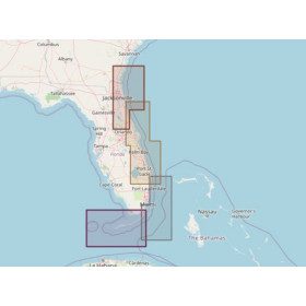
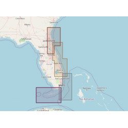
<h2>Marine Card Packs for the Caribbean and West Indies Zone</h2>
<p style="text-align:justify;"><span>The nv-charts are characterized by fine contours and easily distinguishable colour graduations of the depth lines: turquoise for coral reefs, red for the 2-metre line and blue for the 5-metre zones. </span><span>Presented in a practical and user-friendly format (A3 closed and A2 open), a thick plastic envelope protects the cards, making them easy to store. </span><span>The importance of a good graphic representation of the topography when navigating in the Caribbean is essential.</span><br /><br /><span>Well-marked rivers, towns and street maps all contribute to a clear overview of the islands' waterfront facilities. Red numbered waypoints with coordinates based on WGS 84 allow mariners to navigate with their GPS instruments. Heights and depths are shown in the internationally recognized metre format. Large-scale approaches and land contour markings simplify entry into anchorages.</span></p>
<h2 style="text-align:justify;"><span style="color:#ff0000;">Picksea is Premium Reseller of NV-Charts</span></h2>
<h2><span>Features of NV-Charts Caribbean Zone Packs</span></h2>
available
-
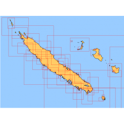
<div class="fiche-txt">
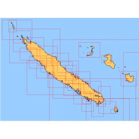
<h2>Choose from the list below an unfolded nautical chart covering the navigation areas around New Caledonia</h2>
<p>This set of charts covers the entire coastline of New Caledonia in unfolded Shom marine charts delivered in a tube. These maps detail precisely the navigation areas of the island. Choose in the list below the area you wish to explore by referring to the chart number associated with the desired navigation area. Indicate the map number you have chosen in the commentary of your order.</p>
<h2>List of chart references and areas covered:</h2>
</div>
available
-
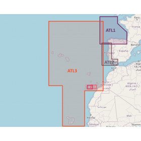
<h2>Atlantic Zone Sea Card Packs</h2>
<p>The nv-charts are characterized by fine contours and easy to distinguish colour graduations of the depth lines: turquoise for coral reefs, red for the 2-metre line and blue for the 5-metre zones. Presented in a practical and user-friendly format (A3 closed and A2 open), a thick plastic envelope protects the charts, making them easy to store. The importance of a good graphic representation of the topography when navigating the Atlantic is essential.<br /><br />Well-marked rivers, towns and street maps all contribute to a clear overview of the islands' waterfront facilities. Red numbered waypoints with coordinates based on WGS 84 allow mariners to navigate with their GPS instruments. Heights and depths are shown in the internationally recognized metre format. Large-scale approaches and land contour markings simplify entry into anchorages.</p>
<h2><span style="color:#ff0000;">Picksea is Premium Reseller of NV-Charts</span></h2>
<h2>NV-Charts Atlantic Zone Marine Card Packs Features</h2>
available