available


€70.00 Tax included
error
Shipped according to supplier's deadline
-
Livraison en points relais : Gratuit
Une question ?
+33 2 97 11 80 95
Detailed features
Admiralty Marine Map of the Antarctic Region
One of the only nautical chart references including the entire Antarctic. It will appeal to Vendée Globe fans who will be able to follow their favourite candidates around the Antarctic continent with a gnomonic projection instead of the classic Mercator projection which cannot be used in latitudes above 70° N or S.
Characteristics of the Admiralty map of Antarctica
- ADMIRALTY Chart 4009: a flat map of the Antarctic region
- scale: 1:150000 published by ADMIRALTY, the United Kingdom Hydrographic Office.
- Edition: August-94.
- Size folded in 2: 71.5 x 53.5cm.
In the same category
4 other products seleted for you-
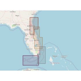
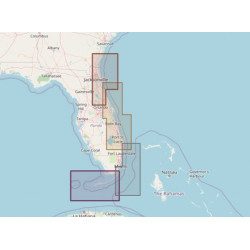
<h2>Atlantic Zone Sea Card Packs</h2>
<p>The nv-charts are characterized by fine contours and easy to distinguish colour graduations of the depth lines: turquoise for coral reefs, red for the 2-metre line and blue for the 5-metre zones. Presented in a practical and user-friendly format (A3 closed and A2 open), a thick plastic envelope protects the charts, making them easy to store. The importance of a good graphic representation of the topography when navigating the Atlantic is essential.<br /><br />Well-marked rivers, towns and street maps all contribute to a clear overview of the islands' waterfront facilities. Red numbered waypoints with coordinates based on WGS 84 allow mariners to navigate with their GPS instruments. Heights and depths are shown in the internationally recognized metre format. Large-scale approaches and land contour markings simplify entry into anchorages.</p>
<h2><span style="color:#ff0000;">Picksea is Premium Reseller of NV-Charts</span></h2>
<h2>NV-Charts Atlantic Zone Marine Card Packs Features</h2>
available


-
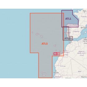
<div class="fiche-txt">
<h2>Choose from the list below an unfolded chart covering the sailing areas around the North and South Atlantic and the Indian Ocean</h2>
<p>These charts detail the sailing areas centered on the North and South Atlantic, the macro sailing areas of North and South America, Western Europe, Western Africa and the Indian Ocean. Delivered unfolded in a transport tube, these charts will serve as a support to trace your journey between continents. Choose from the list below the area you wish to explore by referring to the map number associated with the desired navigation area. Indicate the map number you have chosen in the comments of your order.</p>
<h2>List of chart references and areas covered:</h2>
</div>
available
-
<h2>Marine Card Packs for the Caribbean and West Indies Zone</h2>
<p style="text-align:justify;"><span>The nv-charts are characterized by fine contours and easily distinguishable colour graduations of the depth lines: turquoise for coral reefs, red for the 2-metre line and blue for the 5-metre zones. </span><span>Presented in a practical and user-friendly format (A3 closed and A2 open), a thick plastic envelope protects the cards, making them easy to store. </span><span>The importance of a good graphic representation of the topography when navigating in the Caribbean is essential.</span><br /><br /><span>Well-marked rivers, towns and street maps all contribute to a clear overview of the islands' waterfront facilities. Red numbered waypoints with coordinates based on WGS 84 allow mariners to navigate with their GPS instruments. Heights and depths are shown in the internationally recognized metre format. Large-scale approaches and land contour markings simplify entry into anchorages.</span></p>
<h2 style="text-align:justify;"><span style="color:#ff0000;">Picksea is Premium Reseller of NV-Charts</span></h2>
<h2><span>Features of NV-Charts Caribbean Zone Packs</span></h2>
available
-
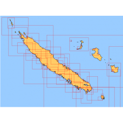
<div class="fiche-txt">
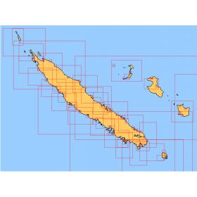
<h2>Choose from the list below an unfolded nautical chart covering the navigation areas around New Caledonia</h2>
<p>This set of charts covers the entire coastline of New Caledonia in unfolded Shom marine charts delivered in a tube. These maps detail precisely the navigation areas of the island. Choose in the list below the area you wish to explore by referring to the chart number associated with the desired navigation area. Indicate the map number you have chosen in the commentary of your order.</p>
<h2>List of chart references and areas covered:</h2>
</div>
available