available


Detailed features

Choose from the list below an unfolded nautical chart covering the navigation areas around New Caledonia
This set of charts covers the entire coastline of New Caledonia in unfolded Shom marine charts delivered in a tube. These maps detail precisely the navigation areas of the island. Choose in the list below the area you wish to explore by referring to the chart number associated with the desired navigation area. Indicate the map number you have chosen in the commentary of your order.
List of chart references and areas covered:
| 6540 | St. Vincent Bay |
| 6553 | Kouaoua Bay |
| 6554 | Chasseloup Bay - Anse Vavouto |
| 6589 | Canala Bay |
| 6686 | New Caledonia (South-East part) - Loyalty Islands |
| 6687 | Approaches to Nouméa - Boulari and Dumbéa Passes |
| 6768 | New Caledonia (South part) - Ile des Pins |
| 6770 | Southwestern approaches to the Isle of Pines - Kuto and Kanuméra bays |
| 6820 | Anchorages of Lifou Island - Baie du Santal |
| 6827 | From Mont Dore to Port-Boisé - Mato and Uatio Passes |
| 6933 | From Ouen Island to Pine Island - Sarcelle Pass |
| 6949 | Surroundings of Thio - From Cap Begat to Toupéti Island |
| 6985 | From Paagoumène to Ouaco |
| 6986 | From Port-Ounia to Cape Ndoua |
| 7011 | From the Neumeni peninsula to Port-Ounia |
| 7049 | From the Loyalty Islands to Hunter Island |
| 7051 | From Cape Colnett to Touho - Approaches to Hienghène |
| 7052 | From Noumea to the Isle of Pines - The large South lagoon |
| 7073 | Harbours and anchorages on the south-east coast of New Caledonia |
| 7097 | Bourail Bay - Coupée Mara and Moindou Bay |
| 7098 | Ouaraï and Chambeyron bays - Ouaraï and Isié passes |
| 7167 | From Saint Vincent Bay to the Coupée Mara |
| 7168 | From Bourail Bay to Passe de la Poya |
| 7218 | Ouvéa and Beautemps-Beaupré atolls |
| 7259 | Maré Island |
| 7273 | From Noumea to Saint Vincent Bay |
| 7313 | From Koné pass to Ouaco |
| 7318 | From Poum to Pam Island |
| 7319 | Pam Island to Cape Colnett |
| 7320 | From Koumac to Poum |
| 7322 | From Poya Pass to Muéo Pass |
| 7351 | From Goyeta Pass to Kone Pass - Approaches to Kone |
| 7375 | From Poya Pass to Kone Pass |
| 7643 | Port of Noumea |
| 7644 | Access to the Port of Noumea |
| 7645 | Havannah Canal and Woodin Canal |
| 7758 | Belep Islands - Pott and Art Islands - North Daos Islands |
Consult the entire catalogue of SHOM charts on line by clicking HERE
You might also like 3 other products seleted for you
-
<div class="fiche-txt">
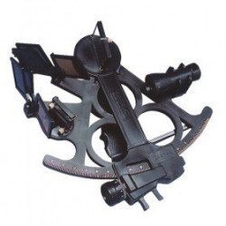
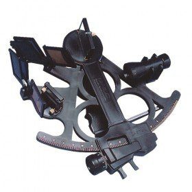
<h2>Sextant Davis Mark 15 from Topoplastic!</h2>
<p>This sextant is the reproduction of a real professional sextant. It is made of modern plastics, but it remains undeformable, shockproof and corrosion-proof. Light, robust and precise, this sextant is an indispensable navigation accessory. The Davis Mark 15 allows you to accurately determine all the points necessary for coastal and astronomical navigation.</p>
<h2>Detailed specifications of the Sextant Davis Mark 15 :</h2>
</div>
available

-
<div class="fiche-txt">
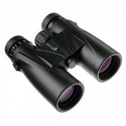
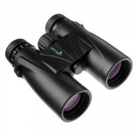
<h2>Shark 10x42: the compact waterproof binoculars for the boat</h2>
<p>Waterproof, the Shark series binoculars are multi-coated. They are gas-filled and have twist-up eye caps. The box includes: binoculars, strap and protective bag.</p>
<h2>Features of the Gambit Shark 10 X 42 waterproof binoculars</h2>
</div>
available
-
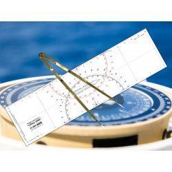
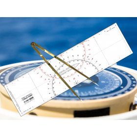
<h2 id="prod-h1" class="prod-name">Ruler and Compass Dry Point Kit</h2>
<p style="text-align:justify;"><span>Set of equipment to prepare for the offshore licence or to equip your boat, including a cras 2000 ruler (Flash-Tide) and a dry point compass (Flash-Tide)</span></p>
<h2 style="text-align:justify;"><span>Features of the Ruler and Compass Kit</span></h2>
available
In the same category
4 other products seleted for you-
<div class="fiche-txt">
<h2>Choose from the list below an unfolded chart covering the sailing areas around the North and South Atlantic and the Indian Ocean</h2>
<p>These charts detail the sailing areas centered on the North and South Atlantic, the macro sailing areas of North and South America, Western Europe, Western Africa and the Indian Ocean. Delivered unfolded in a transport tube, these charts will serve as a support to trace your journey between continents. Choose from the list below the area you wish to explore by referring to the map number associated with the desired navigation area. Indicate the map number you have chosen in the comments of your order.</p>
<h2>List of chart references and areas covered:</h2>
</div>
available
-
<div class="fiche-txt">
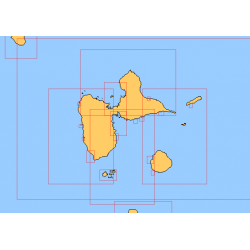
<h2>Choose in the list below a marine map of the surroundings of Guadeloupe</h2>
<p style="text-align:justify;">These SHOM charts cover all the navigation areas around Guadeloupe: from the Saintes to Marie-Galante and la Désirade as well as the Petit and Grand Cul de Sac Marin and the leeward coast, Saint François and Sainte Anne. If you need to reach Pointe à Pitre and the Gosier marina, you should choose the map of the Pointe a Pitre roadstead and the salt river. The Shom L type charts are more adapted to the yachtsman because they are folded in A4 format and thus easier to store in a chart table. They detail precisely the navigation areas of the coasts and islands surrounding Guadeloupe. To order, choose from the list below the area you wish to explore by referring to the map number associated with the desired navigation area. Indicate the map number you have chosen and the option "folded" or "flat".</p>
<h2>List of chart references and areas covered:</h2>
</div>
available
-
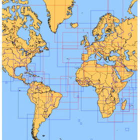
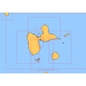
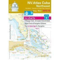
<h2>Marine Card Packs for the Caribbean and West Indies Zone</h2>
<p style="text-align:justify;"><span>The nv-charts are characterized by fine contours and easily distinguishable colour graduations of the depth lines: turquoise for coral reefs, red for the 2-metre line and blue for the 5-metre zones. </span><span>Presented in a practical and user-friendly format (A3 closed and A2 open), a thick plastic envelope protects the cards, making them easy to store. </span><span>The importance of a good graphic representation of the topography when navigating in the Caribbean is essential.</span><br /><br /><span>Well-marked rivers, towns and street maps all contribute to a clear overview of the islands' waterfront facilities. Red numbered waypoints with coordinates based on WGS 84 allow mariners to navigate with their GPS instruments. Heights and depths are shown in the internationally recognized metre format. Large-scale approaches and land contour markings simplify entry into anchorages.</span></p>
<h2 style="text-align:justify;"><span style="color:#ff0000;">Picksea is Premium Reseller of NV-Charts</span></h2>
<h2><span>Features of NV-Charts Caribbean Zone Packs</span></h2>
available
-
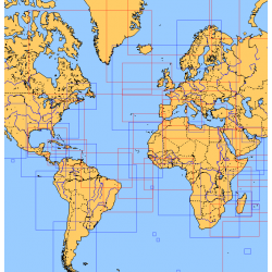
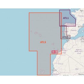
<h2>Atlantic Zone Sea Card Packs</h2>
<p>The nv-charts are characterized by fine contours and easy to distinguish colour graduations of the depth lines: turquoise for coral reefs, red for the 2-metre line and blue for the 5-metre zones. Presented in a practical and user-friendly format (A3 closed and A2 open), a thick plastic envelope protects the charts, making them easy to store. The importance of a good graphic representation of the topography when navigating the Atlantic is essential.<br /><br />Well-marked rivers, towns and street maps all contribute to a clear overview of the islands' waterfront facilities. Red numbered waypoints with coordinates based on WGS 84 allow mariners to navigate with their GPS instruments. Heights and depths are shown in the internationally recognized metre format. Large-scale approaches and land contour markings simplify entry into anchorages.</p>
<h2><span style="color:#ff0000;">Picksea is Premium Reseller of NV-Charts</span></h2>
<h2>NV-Charts Atlantic Zone Marine Card Packs Features</h2>
available