available


Detailed features

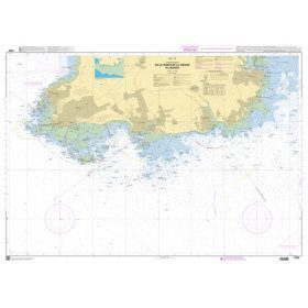
SHOM marine chart 7137 L. Gulf of Morbihan. Scale 1:20000
Folded format A4
You might also like 3 other products seleted for you
-
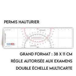
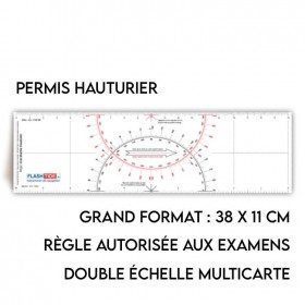
<h2>Flash-Tide - Cras 2000 two-tone ruler</h2>
<p style="text-align:justify;">The Flash-Tide Crash Ruler 2000 is a two-tone red and black crashed ruler that is very popular with boaters and offshore license applicants because it is more practical and easier to read than traditional crashed rulers.</p>
<h2>Details of the Cras 2000 rule</h2>
available

-
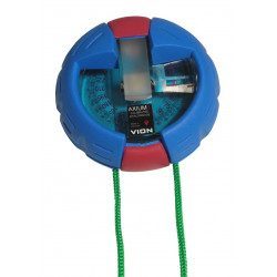
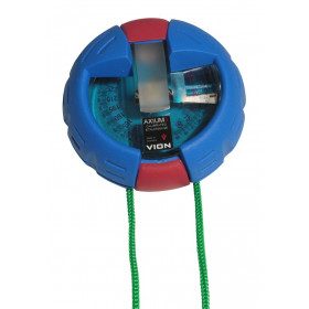
<h2>The VION AXIUM 3 Bearing Compass</h2>
<p style="text-align:justify;">The Axium 3 compass from VION is the "rolls" of the bearing compasses. This model is well known among French boaters for being both solid and extremely reliable. With the Axium 3, you will get all your measurements right the first time!</p>
<h2>Features of the VION Axium 3 bearing compass</h2>
available
-
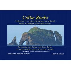
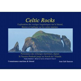
<h2>Celtic Rocks : an original discovery of the Celtic coast from Brittany to Ireland</h2>
<p style="text-align:justify;"><span>Celtic Rocks </span>is a search for the innumerable words of Celtic origin describing the shores, scrupulously reported on the marine maps which inevitably lead us to ask these questions: where do these words come from? What do they mean?</p>
<p style="text-align:justify;">From 250 photos and map extracts, Jean Gab Samzun offers you through this book to open your eyes in search of clues to read in the past and discover the origin of names, ports, anchorages, rocks of the whole coast from the Loire estuary to the north-west of Ireland through the Iroise and the Scilly.</p>
<p style="text-align:justify;"><span>Celtic Rocks</span> is both a beautiful and useful book: it will find its place in your living room as well as on board your boat, discovering the historical, geological and linguistic origins of all your Celtic sailing areas.</p>
<h2 style="text-align:justify;">Celtic Rocks Features</h2>
available
In the same category
4 other products seleted for you-
<h2>SHOM Marine Chart 7250L - From Pointe de la Torche to Loctudy</h2>
<ul>
<li>Scale 1:20000</li>
<li>Folded</li>
</ul>
available
-
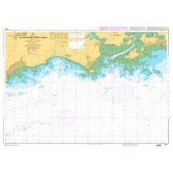
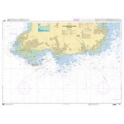
<p>Marine chart SHOM 7135 L. From the point of Saint Jacques to Damgan. Scale 1:15000.</p>
available
-
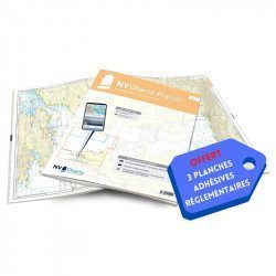
<h2>NV-CHARTS FR5 - 29 South West Brittany nautical charts (from Douarnenez to Lorient) + the 3 statutory adhesive sheets</h2>
<p><span style="font-size:10pt;">In this NV-Charts FR5 pack, you will find an Atlas of <span>29 charts of South-West Brittany, from Douarnenez to Lorient, including 2 deep-sea charts, 11 coastal charts and 16 detailed charts</span>. With a personal download code, you will have access to all the maps in digital format as well as the <strong>NV Graphical Navigator light navigation software</strong> both freely usable on PC, tablets or smartphone!</span></p>
<p><span style="font-size:10pt;">The areas represented are: <strong>South West Brittany Douarnenez, Sein, Audierne, Guilvinec, Loctudy, Bénodet, Port La Forêt, Concarneau, Les Glénan, Aven Belon, Doëlan, Groix, Lorient(FRANCE).</strong></span></p>
<p><span style="font-size:10pt;"><span style="color:#ff0000;"><strong>Free with your FR5 pack:</strong></span> 3 adhesive sheets containing the mandatory regulatory documentation (RIPAM, buoys and flags) for navigation in coastal areas (art 242-2.04 of Division 240). <span style="color:#ff0000;"><strong>When you buy your pack, you have all the regulatory documentation for sailing within 6 miles of a shelter.</strong></span></span></p>
<h2>Description of the FR5 card pack</h2>
available
-
<h2>NV-CHARTS FR4 - 33 West Brittany Marine Charts (from the Seven Islands to Douarnenez) + the 3 regulatory adhesive sheets</h2>
<p><span style="font-size:10pt;">In this pack NV-Charts FR4, you will find an Atlas of 33 nautical charts from the Seven Islands to Douarnenez<span> including 2 offshore maps, 13 coastal maps and 18 detailed maps</span>. With a personal download code, you will have access to all the maps in digital format as well as the <strong>NV Graphical Navigator light navigation software</strong> both freely usable on PC, tablets or smartphone!</span></p>
<p><span style="font-size:10pt;">The areas represented are: <strong>Western Brittany - Roscoff, Morlaix, Ouessant, Molène, Brest, Camaret, Crozon, Morgat, Douarnenez, Sein (FRANCE).</strong></span></p>
<p><span style="font-size:10pt;"><span style="color:#ff0000;"><strong>Free with your FR4 pack:</strong></span> 3 adhesive sheets containing the mandatory regulatory documentation (RIPAM, buoys and flags) for navigation in coastal areas (art 242-2.04 of Division 240). <span style="color:#ff0000;"><strong>When you buy your pack, you have all the regulatory documentation for sailing within 6 miles of a shelter.</strong></span></span></p>
<h2>Description of the FR4 card pack</h2>
available