available


Detailed features

SHOM marine chart 7141 L. Quiberon Bay. Scale 1:20000
SHOM chart.
In the same category
4 other products seleted for you-
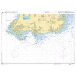
<p>Marine chart SHOM 7135 L. From the point of Saint Jacques to Damgan. Scale 1:15000.</p>
available
-
<h2>SHOM Marine Chart 7250 - From Pointe de la Torche to Loctudy</h2>
<ul>
<li>Scale 1:20000</li>
<li>Flat chart</li>
</ul>
available

-
<p>SHOM marine chart 7137 L. Gulf of Morbihan. Scale 1:20000</p>
available
-
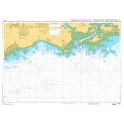
<p>Nautical chart SHOM 7145L. From Triballe to Pornichet. Scale: 1:25000.</p>
available