")
")
")
Detailed features

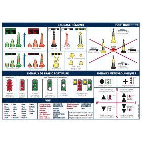
A5 adhesive marine code Maritime buoyage
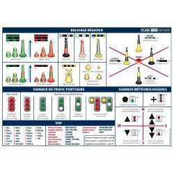
The A5 sticky marine code for ships Buoyage region A (Europe, Africa, Asia, Oceania) displays the essential navigation rules concerning the buoys in maritime navigation. It can replace the compulsory document on Buoyage. CONFORMS TO D240
Characteristics of the Marine Code Maritime buoyage
The adhesive marine code for boats Beaconing region A (Europe, Africa, Asia, Oceania) displays the essential navigation rules concerning beacons in maritime navigation. It can replace the mandatory document on the RIPAM on board in basic or coastal navigation (according to the provisions of division 240*).
The A5 format of the adhesive allows it to be easily placed on board the boat outside or in the cabin.
Extract from Division 240 (version applicable on June 1, 2019) - Article 240-2.04: coastal armament and safety equipment for recreational vessels sailing from 2 to less than 6 miles from a shelter.
.../...
8. A document describing the marking system of the area frequented, possibly in the form of self-adhesive plates ...
- Size of each sheet: A5 (21 x 15 mm)
- MYLAR support
- Quadricolour Edition
In the same category
4 other products seleted for you-
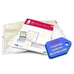
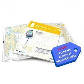
<h2>NV-CHARTS FR11 - 42 nautical charts of Corsica + the 3 regulatory adhesive boards</h2>
<p><span style="font-size:10pt;">In this NV-Charts FR11 pack, you will find an Atlas of <span>42 nautical charts of the whole of Corsica including 2 deep-sea charts, 19 coastal charts and 21 detailed charts</span>. With a personal download code, you will have access to all the maps in digital format as well as the <strong>NV Graphical Navigator light navigation software</strong> both freely usable on PC, tablets or smartphone!</span></p>
<p><span style="font-size:10pt;">The areas represented are: <strong>Corsica - Ajaccio, Calvi, Ile Rousse, Bastia, Porto Vecchio, Bonifacio, Lavezzi, Propriano (FRANCE)</strong></span></p>
<p><span style="font-size:10pt;"><span style="color:#ff0000;"><strong>Free with your FR11 pack:</strong></span> 3 adhesive sheets containing the mandatory regulatory documentation (RIPAM, buoys and flags) for navigation in coastal areas (art 242-2.04 of Division 240). <span style="color:#ff0000;"><strong>When you buy your pack, you have all the regulatory documentation for sailing within 6 miles of a shelter.</strong></span></span></p>
<h2>Description of the FR11 card pack</h2>
available
-
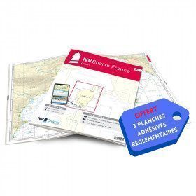
<h2>NV-CHARTS FR5 - 29 South West Brittany nautical charts (from Douarnenez to Lorient) + the 3 statutory adhesive sheets</h2>
<p><span style="font-size:10pt;">In this NV-Charts FR5 pack, you will find an Atlas of <span>29 charts of South-West Brittany, from Douarnenez to Lorient, including 2 deep-sea charts, 11 coastal charts and 16 detailed charts</span>. With a personal download code, you will have access to all the maps in digital format as well as the <strong>NV Graphical Navigator light navigation software</strong> both freely usable on PC, tablets or smartphone!</span></p>
<p><span style="font-size:10pt;">The areas represented are: <strong>South West Brittany Douarnenez, Sein, Audierne, Guilvinec, Loctudy, Bénodet, Port La Forêt, Concarneau, Les Glénan, Aven Belon, Doëlan, Groix, Lorient(FRANCE).</strong></span></p>
<p><span style="font-size:10pt;"><span style="color:#ff0000;"><strong>Free with your FR5 pack:</strong></span> 3 adhesive sheets containing the mandatory regulatory documentation (RIPAM, buoys and flags) for navigation in coastal areas (art 242-2.04 of Division 240). <span style="color:#ff0000;"><strong>When you buy your pack, you have all the regulatory documentation for sailing within 6 miles of a shelter.</strong></span></span></p>
<h2>Description of the FR5 card pack</h2>
available
-
<h2>A5 adhesive marine code Region B</h2>
<p style="text-align:justify;">The A5 sticky marine code for boats in Region B (Americas, Japan, Korea) displays the essential navigation rules concerning the beacons in maritime navigation. It can replace the mandatory document on buoyage. <span style="color:#ff0000;"><strong>CONFORMS TO D240</strong></span></p>
<h2><span>Characteristics of the Marine Code Maritime buoyage Region B</span></h2>
<p></p>
available

-
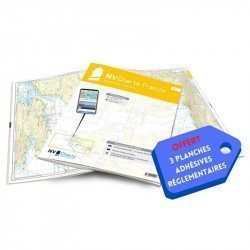
<h2>NV-CHARTS FR9 - 70 Mediterranean Sea charts (from Cap Creus to Toulon) + the 3 regulatory adhesive sheets</h2>
<p><span style="font-size:10pt;">In this NV-Charts FR9 pack, you will find an Atlas of <span>70 Mediterranean charts from Cap Creus to Toulon including 3 offshore charts, 14 coastal charts and 53 detailed charts</span>. With a personal download code, you will have access to all the maps in digital format as well as the <strong>NV Graphical Navigator light navigation software</strong> both freely usable on PC, tablets or smartphone!</span></p>
<p><span style="font-size:10pt;">The areas represented are: <strong>Mediterranean - Port Vendres, Leucate, Canet, Port La Nouvelle, Gruissan, Cap d'Agde, Palavas, Port Camargue, La Grande Motte, Martigue, Carry, Marseille, Calanques, Cassis, La Ciotat, Saint Cyr, Bandol, Toulon (FRANCE)</strong></span></p>
<p><span style="font-size:10pt;"><span style="color:#ff0000;"><strong>Free with your FR9 pack:</strong></span> 3 adhesive sheets containing the mandatory regulatory documentation (RIPAM, buoys and flags) for navigation in coastal areas (art 242-2.04 of Division 240). <span style="color:#ff0000;"><strong>When you buy your pack, you have all the regulatory documentation for sailing within 6 miles of a shelter.</strong></span></span></p>
<h2>Description of the FR9 card pack</h2>
available