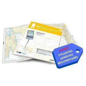
NV-CHARTS FR11 - 42 nautical charts of Corsica + 3 regulatory adhesive sheets

€64.90 Tax included
Detailed features
NV-CHARTS FR11 - 42 nautical charts of Corsica + the 3 regulatory adhesive boards
In this NV-Charts FR11 pack, you will find an Atlas of 42 nautical charts of the whole of Corsica including 2 deep-sea charts, 19 coastal charts and 21 detailed charts. With a personal download code, you will have access to all the maps in digital format as well as the NV Graphical Navigator light navigation software both freely usable on PC, tablets or smartphone!
The areas represented are: Corsica - Ajaccio, Calvi, Ile Rousse, Bastia, Porto Vecchio, Bonifacio, Lavezzi, Propriano (FRANCE)
Free with your FR11 pack: 3 adhesive sheets containing the mandatory regulatory documentation (RIPAM, buoys and flags) for navigation in coastal areas (art 242-2.04 of Division 240). When you buy your pack, you have all the regulatory documentation for sailing within 6 miles of a shelter.
Description of the FR11 card pack
- Bound with staples and in a sturdy transparent pocket (A3/A2 format).
- 3 adhesive boards (A5 format)
- Free download of NV Navigator Light software
NV-Charts is a German publisher that has designed and developed a card pack concept that combines the traditional paper form with modern electronics.
The concept is to propose for the navigation area from Toulon to Menton in the same pack paper charts at different scales (from the map of the area covered to the detailed maps of the ports) and the same charts in electronic format that can be used with the NVapp application, i.e. the navigation software of NV-Charts, whose standard version (sufficient for pleasure boating) is free and can be used on any support (Windows, Android, MacOS or Iphone)
In the same category
4 other products seleted for you-
<h2>North Sea Zone Sea Card Packs</h2>
<p>The nv-charts are characterized by fine contours and easy to distinguish colour graduations of the depth lines: turquoise for coral reefs, red for the 2-metre line and blue for the 5-metre zones. Presented in a practical and user-friendly format (A3 closed and A2 open), a thick plastic envelope protects the charts, making them easy to store. The importance of a good graphic representation of the topography when navigating the North Sea is essential.<br /><br />Well-marked rivers, towns and street maps all contribute to a clear overview of the islands' waterfront facilities. Red numbered waypoints with coordinates based on WGS 84 allow mariners to navigate with their GPS instruments. Heights and depths are shown in the internationally recognized metre format. Large-scale approaches and land contour markings simplify entry into anchorages.</p>
<h2><span style="color:#ff0000;">Picksea is Premium Reseller of NV-Charts</span></h2>
<h2>NV-Charts North Sea Zone Marine Card Packs Features</h2>
available

-
<h2>Sea Cards Packs for the Mediterranean Area</h2>
<p>The nv-charts are characterized by fine contours and easy to distinguish colour graduations of the depth lines: turquoise for coral reefs, red for the 2-metre line and blue for the 5-metre zones. Presented in a practical and user-friendly format (A3 closed and A2 open), a thick plastic envelope protects the charts, making them easy to store. The importance of a good graphic representation of the topography when navigating the Mediterranean is essential.<br /><br />Well-marked rivers, towns and street maps all contribute to a clear overview of the islands' waterfront facilities. Red numbered waypoints with coordinates based on WGS 84 allow mariners to navigate with their GPS instruments. Heights and depths are shown in the internationally recognized metre format. Large-scale approaches and land contour markings simplify entry into anchorages.</p>
<h2><span style="color:#ff0000;">Picksea is Premium Reseller of NV-Charts</span></h2>
<h2>Features of NV-Charts Packs - Mediterranean Zone</h2>
available
-
<h2>NV-CHARTS FR5 - 29 South West Brittany nautical charts (from Douarnenez to Lorient) + the 3 statutory adhesive sheets</h2>
<p><span style="font-size:10pt;">In this NV-Charts FR5 pack, you will find an Atlas of <span>29 charts of South-West Brittany, from Douarnenez to Lorient, including 2 deep-sea charts, 11 coastal charts and 16 detailed charts</span>. With a personal download code, you will have access to all the maps in digital format as well as the <strong>NV Graphical Navigator light navigation software</strong> both freely usable on PC, tablets or smartphone!</span></p>
<p><span style="font-size:10pt;">The areas represented are: <strong>South West Brittany Douarnenez, Sein, Audierne, Guilvinec, Loctudy, Bénodet, Port La Forêt, Concarneau, Les Glénan, Aven Belon, Doëlan, Groix, Lorient(FRANCE).</strong></span></p>
<p><span style="font-size:10pt;"><span style="color:#ff0000;"><strong>Free with your FR5 pack:</strong></span> 3 adhesive sheets containing the mandatory regulatory documentation (RIPAM, buoys and flags) for navigation in coastal areas (art 242-2.04 of Division 240). <span style="color:#ff0000;"><strong>When you buy your pack, you have all the regulatory documentation for sailing within 6 miles of a shelter.</strong></span></span></p>
<h2>Description of the FR5 card pack</h2>
available
-
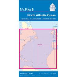
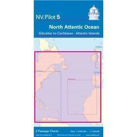
<h2>North Atlantic Offshore Marine Chart | Transatlantic</h2>
<p><span>The NV Pilot 5 offshore chart covers the North Atlantic from Europe to the Caribbean and on the reverse side, an area covering the Atlantic islands: Cape Verde Islands, Canary Islands, Madeira and Azores. The ideal map to prepare a transatlantic voyage.</span></p>
<h2>Details on the NV Pilot 5 map - North Atlantic | Transatlantic</h2>
available