

How to determine a route in direction and distance?

_1.png)
You have opened your chart and plotted the route you want to take from your starting point to the destination you have chosen. You have also checked that there are no major hazards on this route that could interfere with your navigation. You now have to measure the direction of the route to be followed at the helm and determine the distance to be covered to reach this destination using an approximate method or, if you are looking for more precision, with a navigation ruler and a dry point compass.
The approximate method with the chart rose for very short distances
In coastal navigation, when the distance to be covered does not exceed 3 to 4 miles, it is possible to easily determine an approximate route on the chart by using the Declination Rose present on all charts. More specifically, when you want to reach a landmark, for example a distant beacon that is difficult to see clearly on the landscape, you can use the chart's compass rose to determine an approximate course to follow in order to "get closer" to the land mark to be reached so that you can see it and navigate towards it.
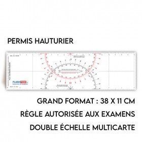
For more precision: use a ruler to determine your route
The Cras ruler is by far the most widely used navigation instrument in France as it has been used for almost 100 years by the French Navy and the Merchant Navy. The Cras ruler is used in maritime navigation or for pleasure boating, both in coastal and offshore navigation. The main advantage of the Cras r uler is that it can be used on the vertical axes of the chart called meridians or on the horizontal axes called parallels. Remember that it is easier to use the parallels when you are close to the north (0° or 360°) and south (180°) directions and simpler to use the meridians when you are more on the west (270°) or east (90°) directions.
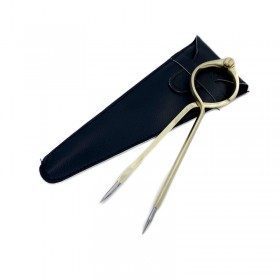
Measuring an accurate distance with the dry point compass
The dry point compass is a "symbolic" instrument of maritime navigation, often assimilated to an element of marine decoration because of its brass construction. In reality, it is a particularly useful tool for the navigator on his chart. It is an essential complement to the navigation ruler and is used to: measure distances accurately on the chart
Linked products