available


Detailed features

Pinoches for the safety of the boat and its crew. Simple and efficient to plug a leaking pipe for example. Set of 10 pinoches.
CARACTERISTIQUES
- C'est qu'en on s'en sert que l'on voit l'intéret de ce précieux élément de sécurité.
In the same category
4 other products seleted for you-
<div class="fiche-txt">
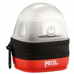
<h2>Storage pouch for headlamp : Noctilight by Petzl</h2>
<p><span>Protective and transport case for Petzl compact headlamps allowing light diffusion in lantern mode. NOCTILIGHT is a protective and light diffusion case for Petzl compact headlamps. A lamp placed inside becomes a lantern with various possibilities of use: placed, suspended in a tent, attached to a belt...</span></p>
<h2>Detailed features of the Noctilight by Petzl</h2>
</div>
available

-
available
-
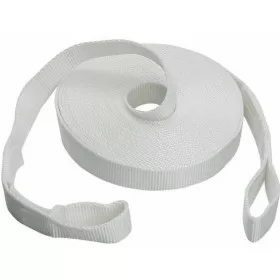
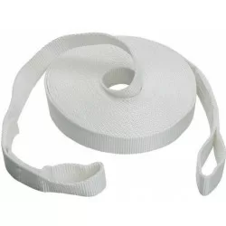
<h2 style="text-align:justify;">Lifelines 11m long</h2>
<p style="text-align:justify;">Lifelines to be fitted flat to the deck. Flat 25 mm webbing, does not roll under feet. Sold in pack of 2 lifelines. Beaking load : 2400 daN</p>
<h2 style="text-align:justify;">Caracteristics of the lifelines 11m long</h2>
available
-
<h2>Navicom handheld VHF RT411+ 6W </h2>
<p>The Navicom RT411+ handheld VHF is the best selling portable VHF. It is very easy to use, compact, robust and reliable. It will accompany you in all your navigations! Waterproof IPX6 and floating, it has a battery life of about 12 hours. </p>
<h2><em>Reminder of the French regulations concerning the use of VHF</em></h2>
<p><em>A maritime radio station licence is mandatory, including for a portable VHF. It can be obtained free of charge from the Agence Nationale de Fréquences by logging on to the anfr.fr website</em></p>
<p><em>In French waters (waters bordering the French coastline up to 12 miles from the coast or the French river network), it is not necessary to have a maritime or river CRR (restricted radiotelephone operator certificate)</em></p>
<p><em>It is forbidden to use a VHF on land</em></p>
<h2>Technical features of VHF RT411+ Navicom</h2>
available