available


€300.70 -10% €270.63 Tax included
error
Shipped according to supplier's deadline
-
Livraison à domicile : Gratuit
Une question ?
+33 2 97 11 80 95
Detailed features
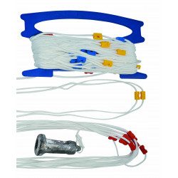
An inflatable IOR pole to easily locate a person in the sea
This pole will allow you to easily locate a person in the water, it provides a buoyancy of 150 N. It is ISAF-ORC and Division 240 compliant as a "device for locating and assisting a person who has fallen overboard".
Characteristics of the Plastimo inflatable IOR pole
- White or yellow ABS box: height 49 cm and diameter 13 cm
- Yellow nylon pole with polyurethane coating
- Height of the part of the pole above the water : 1.98 m
- Ensures the location of a person at sea
- Buoyancy 150 N
-
Equipped with :
- Adjustable strap seat
- Handle easily hangs on the pole when seated
- 0,75 cd light with automatic triggering (8 hours autonomy)
- Red and yellow flag, size 32x20 cm
- Retro-reflective strips with a surface of 200 cm².
- Whistle
- Rigid ballast with V-shaped reinforcements, acting as a keel for optimized stability
- Floating anchor size 28x28 cm
In the same category
4 other products seleted for you-
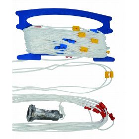
<h2>30 meter hand-held probe line</h2>
<p>Made of 4 mm diameter nylon braid with coloured coils every metre, and a colour change every 10 metres.</p>
<h2>Features of the handheld probe</h2>
available

-
<div class="fiche-txt">
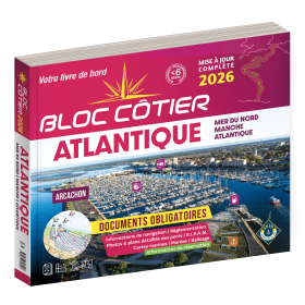
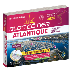
<h2>Indispensable for sailing within 6 miles from a shelter: the Atlantic 2025 Bloc Cotier !</h2>
<p style="text-align:justify;">The Atlantic 2025 bloc cotier is a smaller work than the Marine block, bringing together all the compulsory and regulatory elements on board a boat for coastal sailing, i.e. within 6 miles of a shelter according to the regulations in force. It also offers you access to all the essential documents on board, such as port descriptions and updated maps. With even more photos, the coastal block also includes a complete atlas. The mandatory regulations for 2025 have also been completely updated.</p>
<h2>Detailed summary of the Atlantic Bloc Cotier 2025</h2>
</div>
available
-
<div class="fiche-txt">
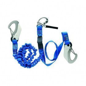
<h2>The Wichard Extendable Harness Lanyard with Manual Release Carabiner</h2>
<div class="fiche-txt">This backup is extendable from 1 to 2 m. There is an overload indicator. Compliant with the EN 1095 standard, it follows the OSR-ISAF recommendations.</div>
<div class="fiche-txt"></div>
<h2>Features of the Wichard Extendable Harness Backup with Manual Release Carabiner</h2>
</div>
available

-
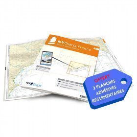
<h2>NV-CHARTS FR10 - 45 Côte d'Azur Nautical Charts (from Toulon to Menton) + the 3 regulatory adhesive boards</h2>
<p><span style="font-size:10pt;">In this NV-Charts FR10 pack, you will find an Atlas of <span>45 Mediterranean Riviera charts from Toulon to Menton and Monaco including 2 offshore charts, 11 coastal charts and 32 detailed charts.</span> With a personal download code, you will have access to all the maps in digital format as well as the <strong>NV Graphical Navigator light navigation software</strong> both freely usable on PC, tablets or smartphone!</span></p>
<p><span style="font-size:10pt;">The areas represented are: <strong>Mediterranean Riviera - Toulon, Hyères, Port Cros, Porquerolles, Fréjus, Saint Raphaël, Cannes, Antibes, Nice, Monaco, Menton (FRANCE).</strong></span></p>
<p><span style="font-size:10pt;"><span style="color:#ff0000;"><strong>Free with your FR10 pack:</strong></span> 3 adhesive sheets containing the mandatory regulatory documentation (RIPAM, buoys and flags) for navigation in coastal areas (art 242-2.04 of Division 240). <span style="color:#ff0000;"><strong>When you buy your pack, you have all the regulatory documentation for sailing within 6 miles of a shelter.</strong></span></span></p>
<h2>Description of the FR10 card pack</h2>
available