available


€84.80 -5% €80.56 Tax included
error
Shipped according to supplier's deadline
-
Livraison en points relais : Gratuit
Une question ?
+33 2 97 11 80 95
Detailed features
An emergency ladder to get back on board
The retracted escape ladder is in the form of a bag with handles that attach along the freeboard or transom and another handle that allows the person in the water to pull the ladder out and back on board.
Characteristics of the Plastimo rescue ladder
- Available in 4 or 5 rungs
- Emergency ladder in the form of a bag with a handle to pull out the ladder
- Each rung measures 18 cm
- The distance between each rung is 30 cm
In the same category
4 other products seleted for you-
<div class="fiche-txt">
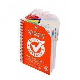
<h2>The Safetics safety guide New version: Sailboats and Motors</h2>
<p><span>All the<strong> good navigation practices</strong> are gathered in this book in the form of clear and easily accessible sheets for everyone. This waterproof guide is i</span><span>It is resistant to sea spray and tears, the guide <strong>SAFETICS</strong> is designed to be used in action and in the moment. It is filled with tips, emergency explanations, help and advice on how to use the<span>memories, of <strong>professional advice. </strong>You will quickly become dependent on this new companion.</span></span></p>
<p>This guide is the result of the work of enthusiasts who decided to create a simple and intuitive memo for pleasure boating. Its content is based on official recommendations, as well as on numerous feedbacks and experts' opinions, including in particular that of <strong>Armel Le Cléac'h </strong>a skipper and professional sailor. It has also been endorsed by the FFVoile, the SNSM, Météo France, the Gendarmerie Maritime, the French Navy and the Centre de Consultation Médicale Maritime. A real Sailor's Checklist for sailing and motor boats.</p>
<h2>Features of the Safetics Sailing Guide: Sailor's Checklist</h2>
</div>
available


-
<p style="text-align:justify;"><span id="result_box" lang="en" xml:lang="en"><span class="hps">Pinoches</span> <span class="hps">for the</span> <span class="hps alt-edited">safety of the boat</span> <span class="hps">and its crew</span><span>.</span> <span class="hps">Simple and efficient</span> <span class="hps">to plug</span> <span class="hps">a</span> <span class="hps">leaking</span> <span class="hps">pipe</span> <span class="hps">for example</span><span>.</span> <span class="hps">Set of 10</span> <span class="hps">pinoches</span><span>.</span></span></p>
available

-
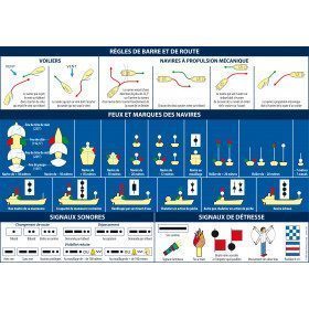
<h2>Adhesive Marine Code A5 Rules of Navigation (RIPAM)</h2>
<p><span>This A5 sticker marine code for ships displays the essential international maritime regulations on the rules of the road and helm in navigation. It can replace the mandatory document (Division 240) on the RIPAM in navigation. </span><span style="color:#ff0000;"><strong>CONFORMS TO D240</strong></span></p>
<h2><span>Features of the RIPAM Marine Code</span></h2>
<p></p>
available

-
<div class="fiche-txt">
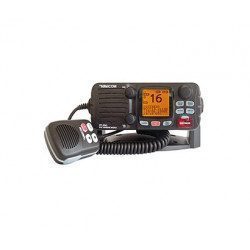
<h2><span><span><span>The FIXED VHF with integrated AIS receiver</span></span></span></h2>
<p><span><span><span>This fixed VHF RT550 from Navicom has a receiver </span></span></span><span><span><span><span>Integrated AIS</span></span></span></span><span><span><span>. It brings together the functions of li</span></span></span><span><span><span><dfn>ais</dfn></span></span></span><span><span><span>ons, transmission of distress messages </span></span></span><span><span><span><dfn>ASN</dfn></span></span></span><span><span><span> and reception of ship identification signals </span></span></span><span><span><span><dfn>AIS</dfn></span></span></span><span><span><span>. Nearby boats equipped with a transponder </span></span></span><span><span><span><dfn>AIS</dfn></span></span></span><span><span><span> are indicated visually on the display. An audible alarm sounds in case of dangerous proximity or risk of collision. Only one VHF antenna is required for reception </span></span></span><span><span><span><dfn>AIS</dfn></span></span></span><span><span><span> and VHF communications. </span></span></span></p>
<p><span><span><span>You will have access to many features with this VHF: 2 levels of power adjustable 1 and 25 W, a customizable display, an emergency call, a group call, an individual call, a dual watch, a position indicator, a transmission and reception level indicator, an intercom, a call log, a memory of the last call, external micro-poing, AIS receiver, alarm volume and key beep control, channel memory scan, priority channel scan, all channel scan, direct access key to channel 16, programmable BEEP keys and keypad lock.</span></span></span></p>
<h2><span><span><span>Features of the fixed VHF with integrated AIS receiver</span></span></span></h2>
</div>
available