available


Detailed features

The 4Water signaling mirror
This mirror could save your life! It has become a mandatory accessory for coastal, semi-offshore and offshore sailing. Lightweight and compact, it will allow you to signal your position using a light (sun, lighthouse, ...).
Features of the 4Water signaling mirror
- Mandatory safety equipment
In the same category
4 other products seleted for you-
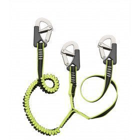
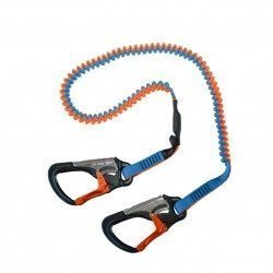
<h2><span>Elastic lanyards with 3 stainless steel snap hooks with double security and automatic closing</span></h2>
<p style="text-align:left;"><span>Very flexible polyester lanyard with retroreflective thread for easy and quick night-time identification. One part in webbing and elastic 23 mm wide and extendable from 1m to 1.50m.</span></p>
<h2><span>Characteristics of the lanyard with 3 carabiners</span></h2>
available


-
<div class="fiche-txt">
<h2>Elastic lifeline - 2 meters - 2 carabiners, Racing version</h2>
<p>This lanyard is a high performance lanyard. This new model has lighter safety lines with a custom clip. It is up to 50% lighter and much more compact than conventional safety lines. Innovation also of the straps thanks to the Dry Coated which allows to reduce the absorption and to remain lighter for longer.</p>
<h2>The detailed characteristics of this Racing life span</h2>
</div>
available
-
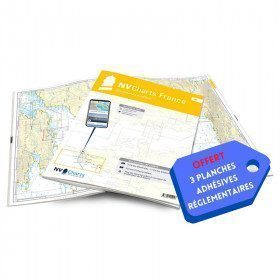
<h2>NV-CHARTS FR9 - 70 Mediterranean Sea charts (from Cap Creus to Toulon) + the 3 regulatory adhesive sheets</h2>
<p><span style="font-size:10pt;">In this NV-Charts FR9 pack, you will find an Atlas of <span>70 Mediterranean charts from Cap Creus to Toulon including 3 offshore charts, 14 coastal charts and 53 detailed charts</span>. With a personal download code, you will have access to all the maps in digital format as well as the <strong>NV Graphical Navigator light navigation software</strong> both freely usable on PC, tablets or smartphone!</span></p>
<p><span style="font-size:10pt;">The areas represented are: <strong>Mediterranean - Port Vendres, Leucate, Canet, Port La Nouvelle, Gruissan, Cap d'Agde, Palavas, Port Camargue, La Grande Motte, Martigue, Carry, Marseille, Calanques, Cassis, La Ciotat, Saint Cyr, Bandol, Toulon (FRANCE)</strong></span></p>
<p><span style="font-size:10pt;"><span style="color:#ff0000;"><strong>Free with your FR9 pack:</strong></span> 3 adhesive sheets containing the mandatory regulatory documentation (RIPAM, buoys and flags) for navigation in coastal areas (art 242-2.04 of Division 240). <span style="color:#ff0000;"><strong>When you buy your pack, you have all the regulatory documentation for sailing within 6 miles of a shelter.</strong></span></span></p>
<h2>Description of the FR9 card pack</h2>
available
-
<div class="fiche-txt">
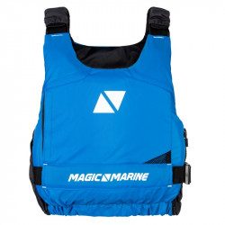
<h2>A buoyancy aid vest without zip to put on</h2>
<p>This lifejacket meets the requirements of the CE ISO 12402-5 standard. It does not have a zip and is easy to put on.</p>
<h2>Discover the Magic Marine 2018 range without further ado</h2>
<p>Do not hesitate to discover all our models of wetsuits, jackets, bags and accessories Magic Marine which works for the comfort and the performance of the sportsmen, professionals and amateurs by proposing them highly qualitative products.</p>
<h2>Characteristics of the Magic Marine Wave Szip buoyancy aid vest</h2>
</div>
available