available


Detailed features

The indispensable tool for the Breton sailor: The Normandy Coastal Almanac 2019
A true bible or Swiss Army knife for professional and amateur sailors. The Normandy Coastal Almanac contains all the necessary and indispensable information for the smooth running of your trips in this region. This reference book is very complete since it contains information on many ports of the English Channel as well as meteorological information such as tide times. Much more than a simple navigation guide, this almanac has for main objective to help the families of sailors in need.
Detailed features of the Normandy coastal almanac
- Port information
- Weather information
- Radionavigation aid
- Signage and markings
- Administrative information
In the same category
4 other products seleted for you-
<div class="fiche-txt">
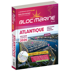
<h2>Indispensable on board your boat: the Atlantic 2025 marine block</h2>
<p style="text-align:justify;">The Atlantic 2024 Marine Block is no longer available. This book contains all the compulsory and regulatory elements on board a boat and offers you access to all the essential documents on board. For this edition, a complete update of the mandatory 2025 regulations has been carried out and you will find <span>in addition </span><span>a special section devoted to new technologies: "electronics - equipment - home automation".</span><span>. </span>Browse the descriptions of the ports and benefit from all the updated approach charts (these are made every year according to the SHOM information). This marine guide allows you to save precious time in order to arrive at the port in complete serenity. A real bible for sailors and yachtsmen, it contains essential information for coastal and deep-sea navigation.</p>
<h2>The marine block for the Atlantic : a navigation area from England to the Azores</h2>
<p style="text-align:justify;">Your marine block allows you to carry all the nautical documents required on board during your navigations. The Atlantic model (new edition 2022) is a great classic of the maritime bookshop and a reference book for sailors. Find our entire collection of coastal and marine pads on our Picksea shop, number one in nautical equipment on the internet.</p>
<h2>Detailed summary of the Atlantic 2025 Marine Block</h2>
</div>
available

-
<h2>Prepare your navigation with this navigation guide!</h2>
<p>This navigation guide: "<strong>Grenada to the virgin islands</strong>" is the English edition of Jacques Patuelli's "Guide to the Lesser Antilles". It is a reference book for those who wish to discover the West Indies by boat. It describes with detail and precision the ports, marinas and numerous anchorages. The presentation of this navigation guide is clear and detailed, there are many photos that complement the maps and plans.</p>
<p>For each port, island or bay: description (location with waypoint, hazards, lights, maps, radio contacts, harbour master's office), cartography, approach (day and night), mooring and anchorage, equipment and services, shore visits, history.</p>
<h2>Detailed features of the "Grenada to the virgin islands" navigation guide</h2>
available
-
<h2>From the calas of Menorca to the great beaches of Formentera, the essential guide to the Balearic Islands!</h2>
<p>Just a day's sail from the French Mediterranean coast, the Balearic Islands are a dream destination. Four islands which have in common a remarkably sunny climate, moderate summer breezes, easily accessible ports and indented coasts where a multitude of coves, each more beautiful than the next, are hidden. Minorca, the most northerly, is also the wildest. Its real little fjords, the roadsteads of Fornells and Port Mahon, offer well-sheltered waters. Mallorca is more grandiose with a very contrasting coastline, from the impressive cliffs of the west coast to the small coves of the east coast, not forgetting the small pearls that are the islands of Cabrera and Dragonera. Ibiza and Formentera are even more sunny and carefree. If their coves and beaches are an invitation to drop anchor, their harbours are always buzzing with life. All the information you need to sail safely. An indispensable book, in addition to the nautical chart and the GPS.</p>
<h2>Features</h2>
available

-
<h2>Prepare your navigation with this navigation guide!</h2>
<p>This sailing guide: "Balearic Islands - Ibiza, Formentera, Mallorca, Cabrera, Menorca" describes the ports, marinas and numerous anchorages in detail and with precision. The presentation of this navigation guide is clear and detailed, with many photos to complement the maps and plans.</p>
<p>For each port, island or bay: description (location with waypoint, hazards, lights, maps, radio contacts, harbour master's office), cartography, approach (day and night), mooring and anchorage, equipment and services, visits on land, history.</p>
<p>This guide covers the coasts of Ibiza, Formentera, Majorca, Cabrera and Menorca.</p>
<h2>Detailed features of the Balearic Sailing Guide</h2>
available