available


You might also like 1 other product seleted for you
-
<div class="fiche-txt">
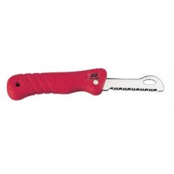
<h2>A floating folding knife to avoid losing it if it falls in the water!</h2>
<p>This folding knife is floating, so it won't end up on the bottom of the water if you accidentally drop it in the water!</p>
<h2>Characteristics of the Plastimo floating folding knife</h2>
</div>
available


In the same category
4 other products seleted for you-
<div class="fiche-txt">
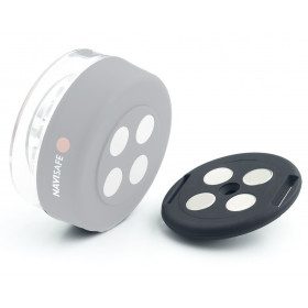
<h2>Navisafe replacement magnet</h2>
<div class="fiche-txt">Navisafe offers replacement magnets for your emergency navigation lights.</div>
<div class="fiche-txt"></div>
<h2>Features of the Navisafe Replacement Magnet</h2>
</div>
available

-
<div class="fiche-txt">
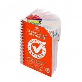
<h2>The Safetics safety guide New version: Sailboats and Motors</h2>
<p><span>All the<strong> good navigation practices</strong> are gathered in this book in the form of clear and easily accessible sheets for everyone. This waterproof guide is i</span><span>It is resistant to sea spray and tears, the guide <strong>SAFETICS</strong> is designed to be used in action and in the moment. It is filled with tips, emergency explanations, help and advice on how to use the<span>memories, of <strong>professional advice. </strong>You will quickly become dependent on this new companion.</span></span></p>
<p>This guide is the result of the work of enthusiasts who decided to create a simple and intuitive memo for pleasure boating. Its content is based on official recommendations, as well as on numerous feedbacks and experts' opinions, including in particular that of <strong>Armel Le Cléac'h </strong>a skipper and professional sailor. It has also been endorsed by the FFVoile, the SNSM, Météo France, the Gendarmerie Maritime, the French Navy and the Centre de Consultation Médicale Maritime. A real Sailor's Checklist for sailing and motor boats.</p>
<h2>Features of the Safetics Sailing Guide: Sailor's Checklist</h2>
</div>
available

-
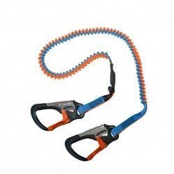
<div class="fiche-txt">
<h2>Elastic lifeline - 2 meters - 2 carabiners, Racing version</h2>
<p>This lanyard is a high performance lanyard. This new model has lighter safety lines with a custom clip. It is up to 50% lighter and much more compact than conventional safety lines. Innovation also of the straps thanks to the Dry Coated which allows to reduce the absorption and to remain lighter for longer.</p>
<h2>The detailed characteristics of this Racing life span</h2>
</div>
available
-
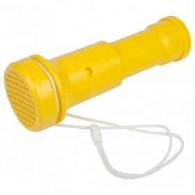
<h2 class="product--view--title">Plastimo Trump horn and foghorn</h2>
<div class="product--view--caption entry mCustomScrollbar _mCS_1 mCS_no_scrollbar">
<div id="mCSB_1" class="mCustomScrollBox mCS-light mCSB_vertical mCSB_inside">
<div id="mCSB_1_container" class="mCSB_container mCS_y_hidden mCS_no_scrollbar_y" dir="ltr">
<div class="pvc-description entry">The simplicity of a foghorn and the power of a horn: over 100 dB without effort. It works by vibration of a thin plastic membrane that can be replaced by any thin plastic film. Wear-free, unalterable, ecological and economical. The Trump is waterproof because it floats.</div>
</div>
<div class="pvc-description entry"></div>
<div class="pvc-description entry">
<ul><li>Diameter 70mm</li>
<li>Weight 140g</li>
<li>Length 195mm</li>
<li>Supplied with cord and 2 spare membranes</li>
</ul></div>
</div>
</div>
available