available


Detailed features

Shom 7076 marine chart for cruising or racing from Saint Nazaire to Saint Malo. Scale: 1:350000
SHOM chart number 7076L. of the Atlantic coast.
In the same category
4 other products seleted for you-
<p>Marine chart SHOM 7135 L. From the point of Saint Jacques to Damgan. Scale 1:15000.</p>
available
-
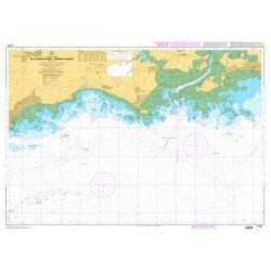
<h2>The SHOM marine chart 7147 L is the marine chart of the Chaussée de Sein to the Pointe de Penmarc'h and the Baie d'Audierne</h2>
<p>Area covered: Raz de Sein, Audierne, Pointe de Penmarc'h. Scale 1:29600.</p>
<h2>Characteristics of the SHOM 7147 L chart (folded version)</h2>
available
-
<p>SHOM marine chart 7251 L. From Loctudy to Concarneau. Scale 1:20 00.</p>
available
-
<p>SHOM marine chart 7252L. Les Glénans. Scale 1:20000</p>
available