available


Detailed features

Tubular radar reflector
This reflector radar for boat with engine has a very practical form: it presents little dunnage and is installed easily. It is a product of complement which does not replace an active radar reflector, and that does not exempt to carry out an active watch. Model with a surface of reflection of 2m2.
Characteristics of the radar reflector
- Motorboat version: with mounting bracket
- Dimensions: Length 56 cm Ø 5 cm
- Weight: 300gr
- Maximum reflection area: 2m2
You might also like 2 other products seleted for you
-
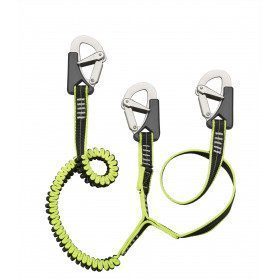
<h2><span>Elastic lanyards with 3 stainless steel snap hooks with double security and automatic closing</span></h2>
<p style="text-align:left;"><span>Very flexible polyester lanyard with retroreflective thread for easy and quick night-time identification. One part in webbing and elastic 23 mm wide and extendable from 1m to 1.50m.</span></p>
<h2><span>Characteristics of the lanyard with 3 carabiners</span></h2>
available


-
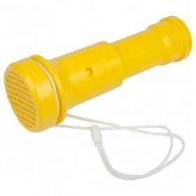
<h2 class="product--view--title">Plastimo Trump horn and foghorn</h2>
<div class="product--view--caption entry mCustomScrollbar _mCS_1 mCS_no_scrollbar">
<div id="mCSB_1" class="mCustomScrollBox mCS-light mCSB_vertical mCSB_inside">
<div id="mCSB_1_container" class="mCSB_container mCS_y_hidden mCS_no_scrollbar_y" dir="ltr">
<div class="pvc-description entry">The simplicity of a foghorn and the power of a horn: over 100 dB without effort. It works by vibration of a thin plastic membrane that can be replaced by any thin plastic film. Wear-free, unalterable, ecological and economical. The Trump is waterproof because it floats.</div>
</div>
<div class="pvc-description entry"></div>
<div class="pvc-description entry">
<ul><li>Diameter 70mm</li>
<li>Weight 140g</li>
<li>Length 195mm</li>
<li>Supplied with cord and 2 spare membranes</li>
</ul></div>
</div>
</div>
available

In the same category
4 other products seleted for you-
<div class="fiche-txt">
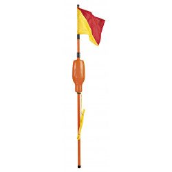
<h2>A stable and ergonomic telescopic IOR pole</h2>
<p>This telescopic IOR pole is very stable and ergonomic. It meets the requirements of the ISAF/ORC racing rules.</p>
<h2>Characteristics of the Plastimo telescopic IOR pole</h2>
</div>
available
-
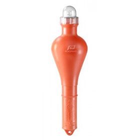
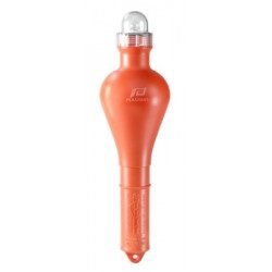
<h2>Floating reversing light with support</h2>
<p style="text-align:justify;">The floating reversing light is an essential accessory to the horseshoe buoy. It is the "Locating and assistance device" provided for in the compulsory equipment of a pleasure boat from a distance of 2 miles from a shelter. This model must be equipped with batteries and its operation must be checked every year.</p>
<h2 style="text-align:justify;">Characteristics of the reversing light</h2>
available
-
<div class="fiche-txt">
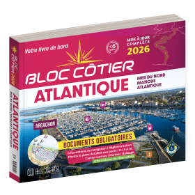
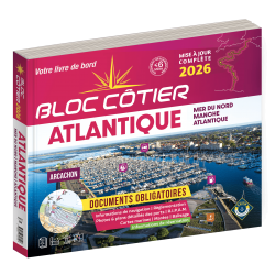
<h2>Indispensable for sailing within 6 miles from a shelter: the Atlantic 2025 Bloc Cotier !</h2>
<p style="text-align:justify;">The Atlantic 2025 bloc cotier is a smaller work than the Marine block, bringing together all the compulsory and regulatory elements on board a boat for coastal sailing, i.e. within 6 miles of a shelter according to the regulations in force. It also offers you access to all the essential documents on board, such as port descriptions and updated maps. With even more photos, the coastal block also includes a complete atlas. The mandatory regulations for 2025 have also been completely updated.</p>
<h2>Detailed summary of the Atlantic Bloc Cotier 2025</h2>
</div>
available
-
<div class="fiche-txt">
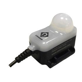
<h2>A flashlight for life jackets : Compulsory equipment when boating</h2>
<p>This flashing light complies with the current boat safety standards (division 240) so that you can be seen in an emergency situation. Designed to be integrated into the CrewSaver lifejackets, it is activated by contact with water in the event of a fall into the water and the opening of the lifejacket. Integrated as standard in the Ergofit Crewsaver range, it can be added as an option on tious other lifejackets.</p>
<h2>Features of the Crewsaver flashlight</h2>
</div>
available