unavailable


Detailed features

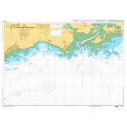
Imray C38 marine chart from Anse de Benodet to Presqu'île de Quiberon
On this edition, the latest survey information has been included where available. The port developments of Lorient and Concarneau and the Glénan Islands are included. The map specification has been improved to show coloured light flashes. A general update has been made.
Maps included:
- Port la Forêt (1:15 000)
- Concarneau (1:15 000)
- Port Manec'h (1:35 000)
- Brigneau & Merrien Ports (1:20 000)
- Doëlan (1:15 000)
- Glénan North Islands (1:30 000)
- Lorient (1:35 000)
- Lorient Yacht Harbour (1:10 000)
- Port Tudy (Island of Groix) (1:10 000)
- Étel (1:35 000)
Characteristics of the Imray C38 marine chart from Benodet to Quiberon
- Publisher Imray
- Edition date 2016
- Scale 1/80000 WGS84
- Printed and corrected in February 2021
- Map size 787 x 1118mm.
- Waterproof.
- Folded in a plastic pocket
In the same category
4 other products seleted for you-
<p>Marine chart SHOM 7135 L. From the point of Saint Jacques to Damgan. Scale 1:15000.</p>
available
-
<p>Nautical chart SHOM 7145L. From Triballe to Pornichet. Scale: 1:25000.</p>
available
-
<p>Marine cartography on SD/MicroSD card compatible with all Garmin portable GPS with mapping. Local delimitation centred on South Brittany.</p>
unavailable

-
available