available


Detailed features

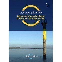
This edition is the essential manual for the preparation of the Offshore course License, which authorizes the operation of a French motorized pleasure craft, day and night, without limitation of distance, tonnage or power.
All topics of the exam are covered in stages.
- step 1: basic concepts
- step 2: calculations and plots
- step 3: additional knowledge
- step 4: reminder and quick preparation for the exam
- step 5: mock exam and answer key 1
- 50 pages. Format: 13.5 x 21 cm
In the same category
4 other products seleted for you-
<div class="fiche-txt">
<h2>The International Regulations for Preventing Collisions at Sea. </h2>
<p>This book will help you to know the international regulations to prevent collisions at sea (or RIPAM in french). <span>This document contains all the rules set out in the International Regulations for Preventing Collisions at Sea, 1972, as amended from time to time.</span></p>
<h2>All the Shom's regulatory works on our website</h2>
You can find on Picksea.com all the regulatory books of the Shom, like the good uses of the nautical documents 1F, or the book on the maritime signalling 3C.</div>
available
-
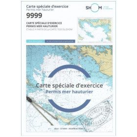
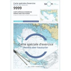
<h2 style="text-align:justify;">SHOM chart 9999 for the french offshore licence exam</h2>
<p style="text-align:justify;">The SHOM chart 9999 is the official chart for the offshore licence examination which allows you to navigate beyond 6 miles from a shelter. The 9999 chart is also used to do all the exercises to prepare for the exam.</p>
<h2 style="text-align:justify;">Training and preparation for the french offshore licence (theory test)</h2>
<p style="text-align:justify;">After passing the coastal licence (and perhaps also the inland waterway licence), you want to extend your navigation area to the "high seas"! To do this, you need to obtain a offshore licence to sail motorboats beyond 6 miles from a shelter (it is also very useful for sailing boats). You can read the article <a href="https://www.picksea.com/en/actualites-et-conseils/post/18-all-knowing-pass-license-holder">"Everything you need to know about the offshore licence"</a>.</p>
<p style="text-align:justify;">The chart 9999 is the official chart to take the offshore licence exam. Of course, this SHOM 9999 chart also allows you to work on all the exercises and mock exams in your school boat or as an independent candidate, to prepare for the tests for the offshore extension of the sea boat licence.</p>
<p style="text-align:justify;">The SHOM 9999 chart is a special marine chart but it contains all the information of a real navigation chart (scale of latitudes and longitudes, coasts, probes, dangers, beacons, lighthouses, currents, ...). You can plot routes and bearings and position points, or measure distances as on a real chart. See the article <a href="https://www.picksea.com/en/actualites-et-conseils/post/49-determine-route-direction-distance">"Determining a route in direction and distance" on our blog</a>.</p>
<p style="text-align:justify;">The SHOM (Services Hydrographique et Océanographique de la Marine) is the public organisation in charge of collecting data (soundings, currents, coastline, ...) and distributing this information, in particular in the form of nautical charts. Find here all our other SHOM charts.</p>
<h2 style="text-align:justify;">Characteristics of the SHOM 9999 Special Offshore Exam Chart</h2>
available

-
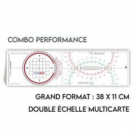
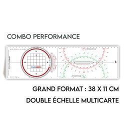
<h2>All the possibilities of the Cras rule and the Rappporteur Breton</h2>
<p style="text-align:justify;"><span>The Antares protractor ruler is both a tricolour Cras ruler AND a Breton protractor. It can be easily adapted to any skipper or sailor, whatever his or her initial training or practice habits. </span></p>
<h2>Features of the Antares rule</h2>
available
-
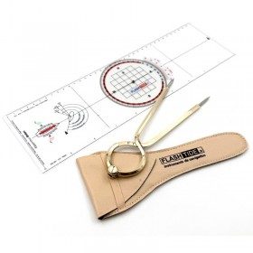
<h2 id="prod-h1" class="prod-name">Protractor Ruler and Compass Kit</h2>
<p style="text-align:justify;">Set of equipment to prepare for the offshore licence or to equip your boat, including a Brocémer ruler (Flash-Tide) and a dry point compass (Flash-Tide)</p>
<h2 style="text-align:justify;"><span>Features of the Protractor Ruler and Compass Kit</span></h2>
available