available


€169.00 -10% €152.10 Tax included
error
Shipped according to supplier's deadline
-
Livraison en points relais : Gratuit
Une question ?
+33 2 97 11 80 95
In the same category
4 other products seleted for you-
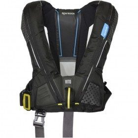
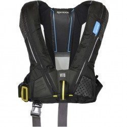
<h2>The reference for Hammar lifejackets: the Spinlock Deckvest Vito 170N HRS</h2>
<p>Deckvest VITO is the latest Spinlock inflatable lifejacket harness technology, based on our design work for the Volvo Ocean Race. All teams were equipped with the same inflatable lifejacket harness developed in collaboration with a core group of Volvo offshore sailors. The lifejacket that the crews wanted to wear more often, with custom features developed, was the basis for the new design. The Harness Release System "HRS" is a plus unlike other lifejackets.</p>
<h2>Characteristics of the Deckvest Vito 170 N HRS Spinlock vest</h2>
available

-
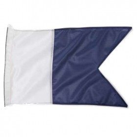
<h2 style="text-align:justify;">Alpha Diving Flag</h2>
<p style="text-align:justify;">The alpha flag indicates snorkelling or underwater diving activities. Must be displayed on the boat, others must pass at least 100 metres away.</p>
<p style="text-align:justify;">Available in size 30x45 cm</p>
available

-
<div class="fiche-txt">
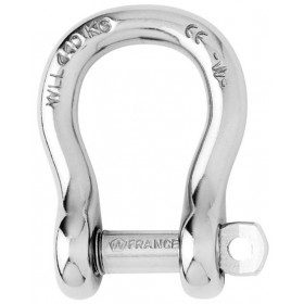
<h2>The Wichard brand reference, the Lyre self-locking shackle</h2>
<p>Wichard self-locking shackles are all forged in France from 316L stainless steel and are known for their properties and performance. The forged notches prevent the shackle from being unscrewed accidentally. This is one of the most important safety features of the boat, so it is important to choose the right diameter according to the estimated workload. The lyre shackle is often used as a link for anchors or dead bodies or on chain terminations.</p>
<h2>All the Wichard fittings are available on Picksea.com, advice and quotation on 02 85 52 65 01</h2>
<p>Discover the wide range of shackles, cleats, pulleys and hardware accessories from leading brands such as Ronstan, Harken, Wichard, Spinlock on our Boat Hardware and Equipment section. Products from the best nautical brands and boat equipment are now available on Picksea, the best selection of nautical equipment.</p>
<h2>Detailed characteristics of Wichard Self-Locking Shackles 4mm to 20mm</h2>
</div>
available

-
<div class="fiche-txt">
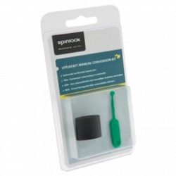
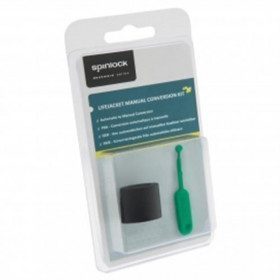
<h2>Switch your Deckvest Spinlock Lifejacket to Manual mode!</h2>
<p>For water sports such as Jet Ski, Wake or Kayak, an automatic vest is not suitable because it would be triggered too easily when in contact with water. For this use, Spinlock recommends the use of this kit to switch your Deckvest UML or Deckvest Lite vest to Manual mode. Installed in a few minutes, this cap allows you to deactivate your UML firing pin so that you can dive into the water without the risk of triggering the inflation of your vest.</p>
<h2>Spinlock Deckware series, boat safety is not a luxury</h2>
<p>The English brand develops and produces safety accessories for the professional and amateur sailor with reference products such as the deckvest 5D, the rolls of the offshore lifejacket, integrating the harness, a flash light, an eye cutter, a retractable anti-spray hood. Essential for the equipment of professional sailors, it is also the choice of demanding boaters in terms of safety at sea.</p>
</div>
available